


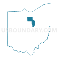
Huron & Ashland Counties PUMA, Ohio
About
Outline
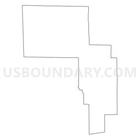
Summary
| Unique Area Identifier | 193720 |
| Name | Huron & Ashland Counties PUMA |
| State | Ohio |
| Area (square miles) | 921.62 |
| Land Area (square miles) | 914.44 |
| Water Area (square miles) | 7.18 |
| % of Land Area | 99.22 |
| % of Water Area | 0.78 |
| Latitude of the Internal Point | 41.00191620 |
| Longtitude of the Internal Point | -82.44524670 |
Maps

Graphs
Select a template below for downloading or customizing gragh for Huron & Ashland Counties PUMA, Ohio


Neighbors
Neighoring Public Use Microdata Area (by Name) Neighboring Public Use Microdata Area on the Map
- Erie & Sandusky Counties PUMA, OH
- Holmes, Guernsey & Coshocton Counties PUMA, OH
- Lorain County (South)--Avon, Avon Lake & North Ridgeville Cities PUMA, OH
- Marion, Knox & Morrow Counties PUMA, OH
- Medina County PUMA, OH
- Richland County PUMA, OH
- Seneca, Crawford & Wyandot Counties PUMA, OH
- Wayne County PUMA, OH
Top 10 Neighboring County (by Population) Neighboring County on the Map
- Lorain County, OH (301,356)
- Medina County, OH (172,332)
- Richland County, OH (124,475)
- Wayne County, OH (114,520)
- Erie County, OH (77,079)
- Sandusky County, OH (60,944)
- Knox County, OH (60,921)
- Huron County, OH (59,626)
- Seneca County, OH (56,745)
- Ashland County, OH (53,139)
Top 10 Neighboring County Subdivision (by Population) Neighboring County Subdivision on the Map
- Ashland city, Ashland County, OH (20,362)
- Norwalk city, Huron County, OH (17,012)
- Willard city, Huron County, OH (6,236)
- Mifflin township, Richland County, OH (6,219)
- Congress township, Wayne County, OH (4,533)
- Bellevue city, Sandusky County, OH (4,527)
- Green township, Ashland County, OH (3,951)
- Jackson township, Ashland County, OH (3,887)
- Berlin township, Erie County, OH (3,723)
- Bellevue city, Huron County, OH (3,673)
Top 10 Neighboring Place (by Population) Neighboring Place on the Map
- Ashland city, OH (20,362)
- Norwalk city, OH (17,012)
- Bellevue city, OH (8,202)
- Willard city, OH (6,236)
- Loudonville village, OH (2,641)
- New London village, OH (2,461)
- Plymouth village, OH (1,857)
- Greenwich village, OH (1,476)
- Monroeville village, OH (1,400)
- Milan village, OH (1,367)
Top 10 Neighboring Unified School District (by Population) Neighboring Unified School District on the Map
- Madison Local School District, OH (27,521)
- Ashland City School District, OH (26,398)
- Norwalk City School District, OH (19,063)
- West Holmes Local School District, OH (18,225)
- Bellevue City School District, OH (13,351)
- Triway Local School District, OH (12,849)
- Firelands Local School District, OH (11,644)
- Willard City School District, OH (11,053)
- Clear Fork Valley Local School District, OH (10,449)
- Black River Local School District, OH (9,949)
Top 10 Neighboring State Legislative District Lower Chamber (by Population) Neighboring State Legislative District Lower Chamber on the Map
- State House District 69, OH (130,902)
- State House District 90, OH (126,807)
- State House District 97, OH (124,815)
- State House District 58, OH (120,471)
- State House District 81, OH (116,551)
- State House District 3, OH (114,520)
- State House District 82, OH (111,625)
- State House District 80, OH (110,118)
- State House District 73, OH (105,536)
Top 10 Neighboring State Legislative District Upper Chamber (by Population) Neighboring State Legislative District Upper Chamber on the Map
- State Senate District 19, OH (406,557)
- State Senate District 13, OH (370,509)
- State Senate District 22, OH (370,237)
- State Senate District 2, OH (363,296)
- State Senate District 26, OH (347,609)
Top 10 Neighboring 111th Congressional District (by Population) Neighboring 111th Congressional District on the Map
- Congressional District 18, OH (653,167)
- Congressional District 16, OH (644,691)
- Congressional District 4, OH (632,771)
- Congressional District 5, OH (627,799)
- Congressional District 9, OH (619,010)
Top 10 Neighboring Census Tract (by Population) Neighboring Census Tract on the Map
- Census Tract 9701, Ashland County, OH (8,353)
- Census Tract 418, Erie County, OH (6,236)
- Census Tract 19, Richland County, OH (6,219)
- Census Tract 403, Erie County, OH (6,170)
- Census Tract 9155, Huron County, OH (6,155)
- Census Tract 9702, Ashland County, OH (5,845)
- Census Tract 20, Richland County, OH (5,619)
- Census Tract 9706, Ashland County, OH (5,371)
- Census Tract 9707, Ashland County, OH (5,288)
- Census Tract 9765, Holmes County, OH (5,189)
Top 10 Neighboring 5-Digit ZIP Code Tabulation Area (by Population) Neighboring 5-Digit ZIP Code Tabulation Area on the Map
- 44691, OH (43,753)
- 44805, OH (32,345)
- 44903, OH (25,602)
- 44857, OH (23,805)
- 44905, OH (14,513)
- 44811, OH (12,867)
- 44090, OH (11,504)
- 44890, OH (11,162)
- 44287, OH (7,559)
- 44889, OH (6,703)